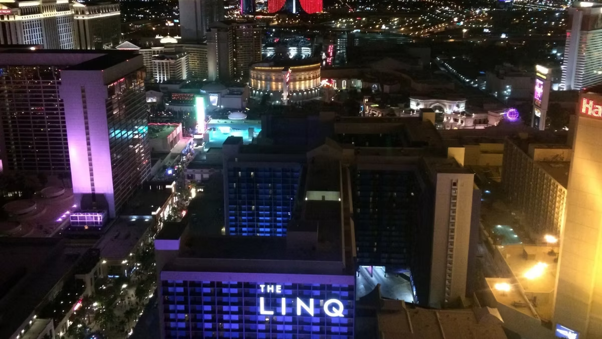
At 550 feet, the LINQ High Roller offers 360-degree panoramic views of the entire Las Vegas Strip, the Nevada desert, and three mountain ranges. To the south you see the Bellagio, Caesars Palace, and the Eiffel Tower replica at Paris Las Vegas. To the north, Downtown Las Vegas and the STRAT tower. To the west, the Spring Mountains and Red Rock Canyon. To the east, the open desert valley stretching toward Boulder City. The view rotates continuously throughout the 30-minute ride.
Standing at the peak of the LINQ High Roller at 550 feet, with floor-to-ceiling glass in every direction and the entire Las Vegas Strip laid out below, is one of those genuinely jaw-dropping moments that visitors describe long after they’ve left Nevada. But knowing what you’re looking at — which tower, which hotel, which mountain range — transforms the experience from impressive to extraordinary. This landmark-by-landmark guide tells you exactly what to look for in every direction during your 30-minute rotation.
Top Tickets
# High Roller Standard Ticket
# High Roller Happy Half Hour Ticket
Table of Contents
How the View Works on the High Roller
Unlike a static observation deck, the High Roller’s view is continuously changing. As the wheel rotates over 30 minutes, your perspective shifts through all four compass directions. The cabin itself does not rotate — it stays level — but the wheel’s movement means that every side of the cabin faces a different direction at different points in the ride. The audio commentary is synchronised with your position, calling out landmarks as they come into your sightline.
A useful mental map: as you board at ground level and begin to rise, the south-facing side of the cabin (toward Bellagio and Caesars) faces the most iconic stretch of the Strip. Position yourself there early — it is the most photographed vantage point — then move around the cabin as you climb to capture the other directions.
South: The Heart of the Las Vegas Strip
Looking south from the High Roller at peak height, you see the densest concentration of the Las Vegas Strip’s most iconic properties: the Bellagio and its dancing fountains, Caesars Palace, the Eiffel Tower replica at Paris Las Vegas, Bally’s, the Flamingo, and the widening Boulevard corridor stretching toward the Luxor pyramid and the Mandalay Bay. On a clear day, the view extends 15–20 miles to the southern valley.
Landmarks Visible to the South
- Bellagio: The most recognisable Las Vegas landmark from above — the oval lake with the dancing fountains is clearly visible. If you time your ride during a fountain show (typically on the hour and half-hour), you’ll see it in full from above.
- Caesars Palace: The sprawling complex directly south-west — identifiable by the Forum Shops dome and the distinctive curved towers
- Paris Las Vegas Eiffel Tower: The half-scale replica rises clearly above the mid-Strip roofline — its latticed iron structure is unmistakable from the High Roller’s elevation
- Bally’s / Horseshoe Las Vegas: The large hotel immediately adjacent to Paris Las Vegas, undergoing ongoing renovation
- Cosmopolitan of Las Vegas: The distinctive stacked-floor profile of the Cosmopolitan towers rises between Bellagio and Caesars
- MGM Grand: The large emerald-green tower visible further south along the Strip
- Luxor pyramid: On clear days, the distinctive black pyramid and the Luxor Sky Beam (only visible at night) are visible 3 miles south
- Mandalay Bay: The gold-glass tower at the far south end of the Strip — visible 4 miles away on clear days
Bellagio Fountain Timing
Bellagio fountain shows run typically every 30 minutes in the afternoon and every 15 minutes in the evening. If you time your boarding so that you reach peak height (around minute 15 of the ride) during a scheduled show, you’ll see the fountains from directly above — a perspective available nowhere else in Las Vegas. Check the Bellagio fountain schedule on the day of your visit. For the best fountain view from the High Roller, target a 5:30 pm or 6:00 pm ride in summer months when evening shows begin.
North: Downtown Las Vegas and the STRAT
Looking north from the High Roller, you see the full length of the Las Vegas Strip extending toward Downtown, with the STRAT tower (809 feet) dominating the northern skyline. Beyond the STRAT, the low-rise grid of Downtown Las Vegas is visible, and on very clear days the Spring Valley and North Las Vegas suburban areas stretch toward the Nevada state border.
Landmarks Visible to the North
- The STRAT Tower: The tall needle-like structure north of the Strip — at 809 feet it is higher than your own position on the High Roller and clearly visible
- Wynn Las Vegas and Encore: The distinctive curved bronze-glass towers visible mid-range to the north-northwest
- Treasure Island and The Venetian: The mixed roofline of these adjacent properties is visible roughly one mile north
- Las Vegas Convention Center: The large flat-roofed complex north of the hotel corridor — most visible during quiet periods between convention weeks
- Downtown Las Vegas / Fremont Street: The low-rise urban grid of Downtown is visible approximately 3 miles north — the Fremont Street Experience canopy is identifiable at night by its LED display glow
West: The Spring Mountains and Red Rock Canyon
The western view from the High Roller delivers one of the most dramatic natural backdrops in Nevada — the Spring Mountains rise to over 11,000 feet approximately 15–20 miles west of the Strip. Charleston Peak (11,918 feet), the highest point in the range, is visible on clear days. Red Rock Canyon’s distinctive red sandstone escarpment is visible to the southwest. Snow caps the peaks from November through April.
Natural Landmarks Visible to the West
- Spring Mountains (Mount Charleston range): The dominant western skyline — a continuous ridge reaching 11,000+ feet. Snow-capped from late autumn through spring, providing a stunning contrast with the desert city below
- Charleston Peak: The highest visible point in the range at 11,918 feet — identifiable as the prominent snow-capped summit in the northwest quadrant
- Red Rock Canyon National Conservation Area: The distinctive reddish-orange escarpment is visible to the southwest, approximately 17 miles from the Strip. The layered canyon walls are most clearly visible in low-angle morning or evening light
- Summerlin: The planned western suburb of Las Vegas — visible as a grid of residential streets butting up against the base of the Spring Mountains
Best Time for the Western View
The western view is most spectacular at sunset, when the Spring Mountains catch the last warm light of the day while the Strip begins to glow below. This is one of the primary reasons the sunset boarding window is so strongly recommended — the eastern neon spectacle and the western mountain sunset happen simultaneously at the peak of your ride.
East: The Desert Valley and Beyond
Looking east from the High Roller, the Las Vegas Valley opens into the flat Nevada desert stretching toward Boulder City and Lake Mead, approximately 25 miles east. The eastern suburbs of Henderson are visible as a low residential grid, and on exceptionally clear days, the peaks of the River Mountains near Boulder City are just visible on the horizon.
What to Look for to the East
- Henderson: The residential suburb immediately east of the Strip — visible as a broad grid of low-rise development
- US Route 95 / I-515 corridor: The major highway interchange east of the Strip is clearly visible as a ribbon of elevated asphalt
- Harry Reid International Airport (LAS): The airport is approximately 3.5 miles southeast — you may see aircraft on approach or departure paths, which adds a dynamic element to the eastern view
- Boulder City and Lake Mead direction: On the clearest days, the blue-grey shimmer of Lake Mead (30+ miles east) is occasionally visible on the horizon
Looking Down: The LINQ Promenade
Directly below the High Roller lies the LINQ Promenade — the open-air entertainment strip connecting Las Vegas Boulevard to Koval Lane. From 550 feet, you can look straight down into the Promenade and watch tiny figures moving between bars and restaurants. The miniaturised perspective gives a satisfying sense of scale — and makes the LINQ’s famous In-N-Out Burger queue look impressively long from above. After your ride, the Promenade is immediately below for dining and exploration.
Daytime vs Night: How the Views Differ
| Direction | Daytime View | Night View |
|---|---|---|
| South (Strip) | Clear detail of hotel towers, fountains, architecture | Full neon spectacle — individual hotel signs blazing |
| North (STRAT) | The STRAT tower and Strip corridor in sharp relief | The STRAT’s observation deck glows; strip lights stretch north |
| West (Mountains) | Spring Mountains clear and dramatic; Red Rock visible | Dark ridge silhouette against the city glow — atmospheric |
| East (Desert) | Open desert valley, Henderson suburbs, airport traffic | Grid of streetlights extending to the dark desert horizon |
For a complete guide to choosing between a day or night ride: Daytime vs Night Ride — Which Is Better?
Photography Tips for Each Direction
Each compass direction has specific photography considerations. For full camera settings, technique, and timing advice, see our dedicated High Roller Photography Tips guide. A few direction-specific tips:
- South (neon Strip): Night Mode on iPhone or Pro Mode on Android; press lens against glass; shoot during a Bellagio fountain show for bonus drama
- West (mountains): Shoot during the golden hour before sunset for warm light on the mountain faces; HDR helps balance sky and foreground
- Down into the Promenade: Shoot straight down — the geometric pattern of the Promenade from directly above makes an unusual and striking composition
- Panoramic shots: The cabin’s continuous glass walls allow wide-angle panoramas in multiple directions — use your phone’s panoramic mode as you slowly turn
What Is the Visibility Range from the High Roller?
Under typical Las Vegas conditions — which are clear most days of the year — visibility from 550 feet extends 20–30 miles in most directions. The Spring Mountains are visible at 15–20 miles; on exceptional days, features 40+ miles away can be seen. The main visibility reducer in Las Vegas is the occasional dust storm (haboob), which can drop visibility to under a mile. Check the Las Vegas weather forecast before your visit if conditions look uncertain.
Frequently Asked Questions
Can you see the Bellagio fountains from the High Roller?
Yes — clearly. The Bellagio’s oval lake and fountain jets are visible from the south-facing side of the cabin at peak height. If a fountain show is running during your ride, you’ll see it directly from above — a perspective available nowhere else.
Can you see the Grand Canyon from the High Roller?
No. The Grand Canyon is approximately 280 miles from Las Vegas — far beyond visual range from any Las Vegas vantage point. The High Roller’s views extend to approximately 20–30 miles under normal conditions.
Which side of the cabin has the best view?
The south-facing side delivers the most iconic Strip views — Bellagio, Caesars, the Eiffel Tower replica. Position yourself there early. The west-facing side offers the best mountain views. Every side delivers excellent views, so move around throughout the ride.
Can you see the airport from the High Roller?
Yes — Harry Reid International Airport is approximately 3.5 miles southeast and is clearly visible. You may see aircraft on approach or departure, particularly from the east-facing side of the cabin.
Is the view better day or night?
Both are spectacular for different reasons. Day gives clarity and mountain views; night gives the full neon spectacle of the Strip. The sunset transition window delivers both. See our full Daytime vs Night guide.
Can you see Lake Mead from the High Roller?
On exceptionally clear days, the faint shimmer of Lake Mead may be visible on the eastern horizon approximately 30 miles away — but this is not guaranteed. The eastern view is more reliably interesting for the airport, Henderson, and the open desert rather than Lake Mead specifically.
